Sounding the Alarm - Using AI in Disaster Management
Better alerts can save lives in an emergency. Google Crisis Response is using AI for disaster management.
Two weeks before Hurricane Florence made landfall on the North Carolina coast this September, it was forming in the Atlantic Ocean. Florence would turn out to be an unusually slow-moving hurricane, one capable of dropping record rainfall into areas prone to flooding. This unexpected delay in the hurricane’s arrival meant that people had more time to prepare for the storm.
“This was a well-forecasted event several days in advance for such a complicated system”
Sara Jamison, a Senior Service Hydrologist with the National Weather Service
Because of that, people were notified of the conditions, evacuations began, and emergency alerts were disseminated. But that doesn’t mean that everyone got out of the hurricane’s path.

Mor Schlesinger, Manager of Software Engineering for Crisis Response
In response to emergency scenarios like the one presented by Hurricane Florence, people often turn to Google, looking for answers. “Our mission is to organize the world’s information to make it universally accessible,” says Mor Schlesinger, manager of software and engineering at Google. “The times when people need this information the most is in times of crisis.”
In 2010, a fire broke out in Israel’s Carmel Mountains. Yossi Matias, VP Engineering at Google and Head of Israel R&D Center, could see the fire from an office window but couldn’t find any helpful information about it online. So they shifted gears and got to work on a way to change that. In a matter of a few hours, the small team coordinated with the local government, surfaced the relevant emergency information and resources, and made them available through Google Search.
That experience of creating the first alert crystallized the fact that there was a need to organize information in emergency scenarios.
In situations of crisis, people are anxiously looking for information that can help them make decisions about how to stay safe,” says Matias, “and we have an opportunity to make that information available to people in those dire moments.
Yossi Matias, VP Engineering at Google and Head of Israel R&D Center.

SOS Alert

Public Alerts
In the midst of a horrible event, it’s a huge relief to find out at least you can know what is going on. What scares us the most is when we don’t have enough information.
Mor Schlesinger, Manager of Software Engineering for Crisis Response.
Crisis Response at Google existed in various forms over the past decade and now has a permanent presence led by Yossi Matias with multiple teams around the world. Since the launch of SOS Alerts in fall 2017, the tools built by the Crisis Response team have been activated during more than 200 crises around the world, and the emergency information provided by SOS Alerts and Public Alerts has been viewed more than 1.5 billion times. The drive for that expansion arises from the mission felt by the team. “Part of our paying it forward is to try and tackle these problems,” says Schlesinger, who came on board to lead engineering efforts for the team. “We’re doing this because we feel this is the right thing to do.
In the United States, during a storm like Florence, which impacted the many rivers that meet the shoreline along the North and South Carolina coasts, Jamison says, “trying to predict things, especially in the situation of a hurricane, can be extremely complex.”
In these cases, what the team can offer is mapping data – layers highlighting the path of a storm, evacuation routes within states or across state lines, shelter locations – as well as alerts. Partnerships with state and local governments make it possible to overlay emergency information about road and bridge closures across state lines. Getting accurate information to people as soon as they need it is of paramount importance during an emergency.
Although there is a robust infrastructure of weather observation and ways to get that information out, there are reasons that keep people from evacuating, even in areas of the United States that are historically prone to flooding. Some families can’t afford to stay elsewhere once they leave home; others can’t afford the gas to get to a safer area, while others simply don’t have a vehicle with which to escape. Beyond economic burdens, some residents often don’t evacuate because they perceive the threat to be sensationalized, leading them to ignore or mistrust warnings.
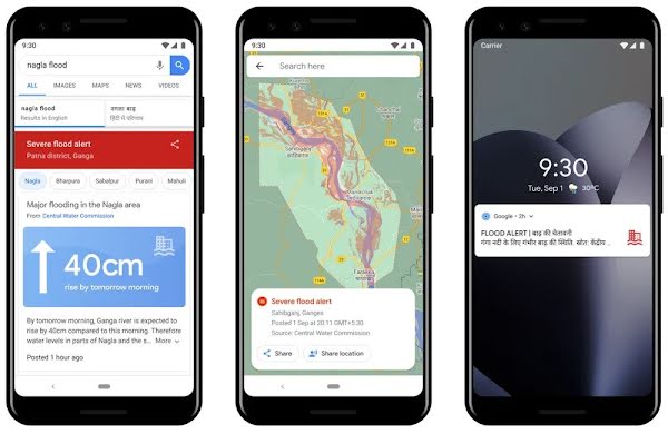
While resources like the Crisis Map contain useful information during emergency scenarios in the United States, events in other parts of the world present a range of different and escalating challenges. In India, where 20 percent of global flood-related fatalities occur – according to flood data compiled from 1953 to 2017 by India’s Central Water Commission – improving flood prediction and warning infrastructure could have a significant impact.
Being able to see these maps that show you the probability of the flood rising at your doors – people never had access to this kind of information in times of crisis before.
Mor Schlesinger, Manager of Software Engineering for Crisis Response.
When activated, the SOS and Public Alerts provide information about water level, why that level is dangerous with historical context, how long that danger may last, recommended action, and where to find additional resources.
It’s a comprehensive resource center from beginning to end, organized in a localized and actionable fashion.
Telling you the flood is coming is great, but hopefully we’re providing a very simple way to understand what is going on and the information needed to make a decision.
Mor Schlesinger, Manager of Software Engineering for Crisis Response.
This infrastructure, for observing the weather patterns that transform rivers and the surrounding land susceptible to flooding, is where the investment in AI for disaster management can have a human impact. As Schlesinger points out, “Putting all of these unique technologies and all the cloud computing together” adds up to the ability to better forecast floods and help the people affected.
Right now, flood-prone areas in India have up to 24-hour notice to evacuate during monsoon season. With the information gathered on the ground, the Crisis Response and Google Research teams hope to extend that window to 72 hours. Making earlier forecasts, and ensuring they’re accurate enough to gain the trust of the people who live in an affected area, could create an environment where more people are able to safely evacuate from areas that suffer regular flooding.


For Schlesinger, the future of Crisis Response involves implementing the tools the team has developed in more locations and unifying those resources in one easily accessible place. That will help to build trust in alerts and the emergency information Google can provide.
At times of crisis you have very little time to make a decision that can affect your life, that can affect the life of your loved ones. So it’s truly important to get the right information concise and complete.
Mor Schlesinger, Manager of Software Engineering for Crisis Response


